Tuesday, May 29, 2012

Crater Lake National Park...and snow!!!

Smith River
On Sunday, we left Eureka and drove north along the coast to Crescent City where we turned eastward. We passed through Redwoods National Park and State Park where we saw thousands and thousands of huge redwood trees towering over the roadway. We crossed the pretty Smith River and stopped to admire and take pictures of it in several spots.

National Creek Falls trail
At some point back on the road, we rounded a bend and saw 6 large elk off to our left! Two of them were grazing lazily (one eyeballing us skeptically as we drove past), and the other four were sitting in the grass which completely obscured all but their huge antlers. It was amazing! Too bad we went sailing past them at 60mph, and so we couldn't get a picture...but it was still fantastic. (Apparently, they're not mythical like we suspect the moose in New England are!)

National Creek Falls
Eventually, we crossed into Oregon and the huge trees and gorgeous scenery just continued. We stopped briefly in Grants Pass and then continued eastward toward Crater Lake. We set up camp late in the day at Diamond Lake RV Park, next to Diamond Lake with Mount Bailey looming behind it covered in snow and thick clouds. We (and by we, I mean, I) shivered through the night in the chilly almost freezing temperatures. Brrr.

Crater Lake visitor center
On Monday morning, we drove toward Crater Lake but first stopped at National Creek Falls. We hiked on a short 1/2 mile downhill trail to the creek where we saw it tumbling over large rocks and spewing mist on everything (including us) around the base of the falls. The falls were only about 80 feet tall and they were partly obscured by the trees nearby, but it was still spectacular. We hiked back up to the car and continued on our way.

Although the campground is only 3 short miles from the north entrance to Crater Lake National Park, we had to use the west entrance some 50 miles away because giant snow drifts remain all over the northern part of the park. We stopped for lunch at Annie Creek Restaurant. The staff all seemed new, which was confirmed when one of them mentioned the restaurant and gift shop had only been open a few days for the beginning of the "summer" season.

Wizard Island in Crater Lake
(I'm in a ski jacket on Memorial Day!!!)
As we drove into the park and ascended the mountain toward the lake, the snow banks increased in depth until we saw that they had drifted over the roof of the visitor center at the Rim Village. HA! (Only a few short weeks ago, we battled 100+ degrees as we entered California, and now we're trudging through snow!) Evidently, two nights before we arrived, another 8 inches of snow fell all over the Crater Lake area, including in our campground. (This area averages over 500 inches of snow every year and it takes the park staff 4 months beginning in April to clear the snow on the north entrance and the drive around the rim. Zounds.)

Crater Lake Lodge Great Room...
Notice the cool bark paneling!
We walked around Rim Village and found the Crater Lake Lodge which was extensively restored in 1994. Apparently it had been considered poorly built and something of a death trap despite the fact that it withstood punishing amounts of snow and harsh winters since it was originally completed in 1915.  We hiked around on the snow banks taking pictures of the beautiful lake and the surrounding mountains. Ken even walked up onto a snow bank that reached above the roof line of one of the buildings. Ah, so breathtakingly pretty.

Crater Lake
We drove on the only section of park road currently open, a short 1.2 mile stretch (out of a total 31 miles) between the Rim Village and Discovery Point. We slogged over the snow and took some more pictures, especially of Wizard Island, a small volcanic peak that formed after the lake began to fill with water. Another much smaller volcanic peak sits very close to the eastern edge of the lake. It resembles a Phantom Ship and so it is named. In warmer months, the trails allow visitors to get fairly close to it, but, alas, we could only barely see it from across the water and it only resembled a tiny lumpy triangle from our vantage point.

Crater Lake and Wizard Island
Crater Lake formed about 7,700 years ago following a series of eruptions of Mount Mazama that depleted the underlying chamber of magma. This depletion caused the mountain to collapse under its own weight and form a giant caldera over 6 miles long and 4.5 miles wide. 

Mount Thielsen
Over time, the caldera filled with rainwater and snowfall. At such a high altitude, no streams run into the lake and the surrounding rim forms a perfect bowl, so no water runs out either. As such, the lake has very little sediment and looks a beautiful azure blue year round. The lake is over 1,900 feet deep at its deepest point adding to its sapphire color. Crater Lake was established as the sixth national park after 17 years of relentless lobbying by William Gladstone Steel, a tireless champion who first read about the lake in a newspaper article in his home state of Kansas at the age of 16.

Ken at Diamond Lake
We left Crater Lake and began our drive back to the RV. Along the way, we stopped to take pictures of snow-capped Mount Thielsen, a jagged volcano typical of the Cascade mountains.

Diamond Lake
We tried in vain to find Lemolo Falls, but it was too late in the day to walk the mile and a half hike down to them. We could, however, see snowy Mount Howlock blanketed with clouds beyond Lemolo Lake as we drove over the dam there. The clouds were beginning to roll in, so we turned back.

We ventured on and ended at Diamond Lake, where we sat on an old log at the edge of the water and watched the sun set behind Mount Bailey across the picturesque water. What a spectacular day.

Monday, May 28, 2012

Eureka...get your freak on!

Sonoma Valley vines
On Friday, the 25th of May, we drove out of Napa Valley and through Sonoma Valley. Wow. What beautiful scenery. Mile after mile of grapevines stretched out over the hillsides. We saw lots of different wineries, each with their dutiful rows of vines like little green soldiers.

Built in 1889 as a wedding gift
from Mr. Carson to his son
We headed north toward Eureka on the coast and found ourselves driving through increasingly narrower and windier roads along the way. We took US 101 which, though technically a highway, is actually more of a slow and scenic route. We were treated to captivating views of the Russian River near Ukiah and towering trees as we drove through several redwood groves and the Avenue of the Giants (more redwoods).

Once at the coast, we could see across Humboldt Bay...well, most of the way. The fog had rolled in from the ocean beyond and began rapidly covering everything in its path in a thick white billowing blanket of mist. It was beautiful, but hard to capture in pictures. The temperature also dropped from a balmy high of mid-70s/low of mid-50s in Napa, to a nippy high of mid-50s/low of mid-30s and rainy in Eureka. Yikes.

The Samoa Cookhouse
We found our campground nestled between a gas station, a Harley dealership and the highway. Sweet. At least it was clean and the manager was very helpful. She gave us a wonderful suggestion for dinner...The Samoa Cookhouse. This restaurant is the last surviving original lumber-camp style cookhouse in the west, built in 1890. Originally a restaurant run by and for the logging company employees, this place continues to serve breakfast, lunch and dinner to hungry diners family style every day. We noshed on roast beef, fried pork chops with gravy, peas (Ken's least favorite veggie), salad, baked potatoes, beef and barley soup, yellow cake with chocolate icing, and the best homemade white bread I've had in a while. Yum. It was all pretty mediocre, but there was a lot of it.

Carson Mansion in Eureka,
ca. 1885, built by William Carson
After dinner, we drove around Eureka and found the Carson Mansion, built in 1885 and now used as a private and very exclusive club known as the Ingomar Club. Across the street is a big pink Victorian home built as a wedding gift by Mr. William Carson to his son in 1889. Afterward, we retired to the RV for happy hour and more Frasier re-runs.

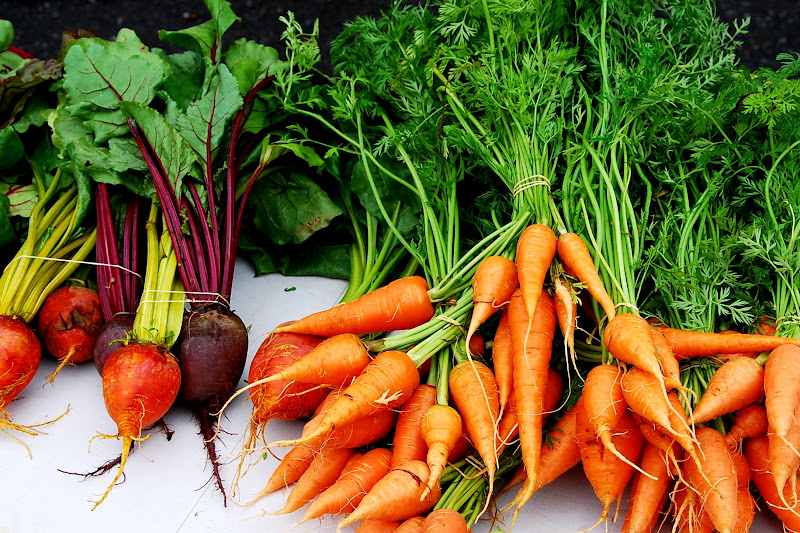
Arcata Farmers' Market
In the morning, we drove up to Arcata at the suggestion of the campground manager to visit the extensive farmers' market and to see the running of the bulls. No. Wait...not bulls. It was much freakier than mere animals.

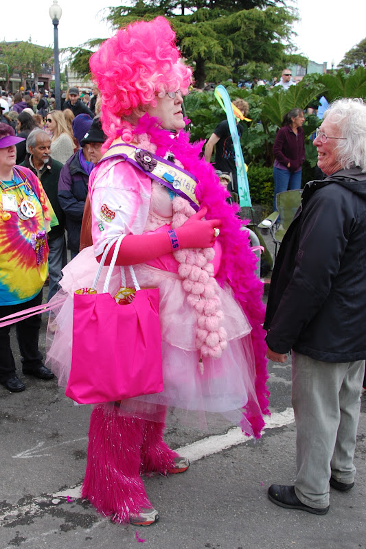
We witnessed the beginning of the Kinetic Sculpture Race, a local tradition made absolutely fun and ridiculous by the hordes of people dressed in their craziest outfits. We were sorely under-dressed for the occasion. To compensate, we took pictures of everyone else. The contestants in the race build a craft that will cross "land, sand, mud and water" in 3 days' time, according to the race website.

"Roadkill"
Firefighters surrounded this Fire Ant when
fire came shooting out of its butt
The race started at the plaza in Arcata where the contestants show off their elaborate art vehicles by cruising around the square 4 or 5 times before racing off for the Manila dunes (through lots of sand) and then to the gazebo in Eureka. Evidently, the second day is spent sailing (or hopefully at least floating) across Humboldt Bay and then up and down a 7% incline. Day Three is through a swamp and then onto dry land before the racers finish in Ferndale...some 42 miles from the starting line.

To our amateur eyes, many of these crafts looked barely able to complete the tour around the plaza, let alone the entire race. We saw a great many different approaches to solving the difficulties of the race's course...some vehicles had water noodles duct-taped around the wheels, others had giant blocks of painted foam attached here and there. Still others had balloon tires, and one even had plastic barrels. They all had a mixture of guts, glory and unchecked creativity. The crowd was awash in piercings, fishnet stockings, feather boas, tattoos and mohawks all to support the racers...though we suspect many of them probably look like that everyday. What an event.

Carter House Inn, Eureka, CA
After the racers were off to their next destination, we wandered around the streets of Arcata looking for our car, who was playing hide and seek from us. Up one street and down several others, eventually we found it hiding between some SUVs on a street we were sure we hadn't left it on (sneaky little devil). In any case, we headed to lunch at a little Indian buffet. In the afternoon, we visited Old Town Eureka, a tiny little section of the town where many of the houses and most of the businesses are in beautiful old Victorian homes and buildings right on the waterfront.

For the Snugs!
We walked around and took pictures (me in my ski jacket!) of the pretty structures on the old brick streets. We wandered in and out of the aisles of the used bookstore on one corner, and found a little street named Snug Alley (for the Snugs!).

We settled in for our last night in California and watched more Frasier re-runs...which has, sadly, taken the place of the roasted marshmallows of last year's trip, but there's a lot of restrictions on campfires in this state, what with its penchant for wildfires.

Speaking of states, it would seem no other state in the Union does springtime quite like California. For all the traffic, congestion and outrageously high gas prices, we have not found another state with more flowers in bloom than this one has been this May.

From the desert with its yellow flowers of the prickly pear cactus and saguaro trees to the mountains covered in rhododendrons in every shade, white and purple lilacs (the size of small houses!), Queen Anne's lace, orange California poppies, giant dogwoods, and the rest of the state swimming in purple lupine, star jasmine, Calla lilies, white and pink oleanders, southern magnolias, daisies, more than a hundred different varieties of roses and a profusion of literally thousands of other flowers and trees whose names I don't know blooming in a kaleidoscope of colors, they have all provided a dazzling array of beauty.

Friday, May 25, 2012

Friends...family...for The Birds!

Millerton Lake
On Tuesday, after toe-dipping one last time in Millerton Lake, we packed up and headed north to Los Gatos, near San Jose. We drove out of the beautiful rolling hills dotted with happy cows and covered with velvety grasses gently bending in the wind, and into a rat's nest of roads choked with traffic.

Once at the house of Ken's friend, Brian, we soon forgot our traveling troubles and settled in for a nice chat on his back porch. Ken and Brian reminisced about old times and old co-workers, dredging up names and events from so long ago that they surprised each other. It was great! We headed off to dinner at Chef Chu's, an veritable institution in Los Altos. We were not disappointed with the fabulous meal and shared Singapore Rice Noodles, Kung Pao Calamari and the largest whole crispy fish I've ever seen on a plate served with sweet and sour sauce. The fish was...odd. The poor thing was staring at me through a thick crust of fried for most of the meal, until Ken and Brian were instructed to eat the eyeballs. They did. I wish I was kidding. The server assured us 'they're good for you'. Whatever. No way I'm eating eyeballs. Jus' sayin'.

In any case, we headed back to Brian's house to assess the RV situation. We decided that parking illegally overnight would probably not be a great idea, so we said our goodbyes to Brian and headed off to find a Walmart parking lot about 20 miles north.

Bodega Bay coastline
In the morning, we headed farther out of the San Jose area, only to find even more traffic while the GPS unit repeatedly shouted at us to turn around. In any case, we eventually found our way and crossed back into a more idyllic area as we entered Napa Valley. We set up camp at Skyline Wilderness Park, a lovely county park at the base of some hills in the middle of wine country.

Schoolhouse from 'The Birds'
We decided, instead of hitting the wineries, we'd head to the coast and visit Bodega Bay, a town known mostly for the filming of Alfred Hitchcock's 'The Birds'. We traveled north along the coast and watched the surf pound the beach and the birds battle the strong winds. We wended our way until we turned off to follow the Russian River east and then turned again to go south along a tiny road until we reached the town of Bodega.

Bodega Country Store
Bodega is home to the schoolhouse filmed in the movie, as well as the St. Teresa of Avila church photographed by Ansel Adams in 1953. We walked around and took pictures of both and then stopped in to the Bodega Country Store, an eclectic mix of firewood, groceries, old magazines, fine gourmet food and the largest collection of
Dinner at Bodega
Country Store
Hitchcock schlock anywhere. We opted for a bowl each of red clam chowder and white clam chowder with a pizza-ette to share. Yum. The chowders were absolutely fantastic, made from old recipes (brothy instead of thickened with flour) according to the owner. While dining on a little old farm table next to a window, we looked out onto the tiny town and read about the filming of some of the movie there. Nice.

St. Teresa of Avila, Bodega, CA
Baker Creek Seed Bank, Petaluma, CA
After our early dinner, we drove back to Petaluma, where we saw an old corner bank repurposed into a
Seed Bank, run by Baker Creek Seed Company. We walked around the bustling little downtown a bit and then continued on our way. With a quick stop at a couple of Goodwills for some books and such, we returned to the RV and settled in for an evening of laughing at old 'Frasier' re-runs on Netflix. Ah, good times.

Old Schools Command, Mare Island
On Thursday, we drove into Vallejo and visited Mare Island, an old Navy base where Ken was stationed back in the day. We found some of the old Schools Command buildings where he took classes and the barracks where he lived, now repurposed into Touro University, with the rest of the old buildings boarded up and in desperate need of repair. In fact the entire old Navy base is mostly old dilapidated structures with broken windows and weeds growing all around. It looks like the perfect setting for a horror movie.

In any case, we next went to visit with my cousin, Sue and her husband, Randy. They live on Mare Island in an adorable community of pretty houses that provides a complete juxtaposition to the near ruin of the Navy base just a few blocks away.

St. Peter's Chapel on Mare Island
After a wonderful lunch and catching up with the two of them, Sue took us on a tour of some of the pretty formerly Navy buildings. We first walked to the oldest Navy chapel west of the Mississippi, built in 1901. It's still used for weddings and such.

Pam and Sue
Next we walked on to some of the old officers' quarters. These grand 4-square houses are, sadly, empty most of the time, but are occasionally rented out for receptions and other events. We peeked in the windows of several of them and saw each home is beautifully appointed with original wood moldings, huge pocket doors and lots of pretty details throughout.

Old Officers Quarters on Mare Island
used in the filming of a new movie!
One house was even used during the recent filming of a new movie with Joaquin Phoenix, Amy Adams and Philip Seymour Hoffman, and Sue thought the name of it would be 'The Master'. She also told us that the island has been used for filming other things as well, including a Jaguar commercial. How fun! We walked through the park (complete with hundreds of concrete bomb shelters) and back to her house and after chatting a bit more, we said our goodbyes.We really enjoyed our visit with Sue and Randy!

Sam and Pam
Next, we drove into Oakland through a fair amount of traffic and found Jack London Square where we had a brew at Miss Pearl's Restaurant and Lounge before heading off to find my friend, Sam's, apartment in the Temescal neighborhood of the city. We caught up with Sam (after about 4 years!!) and had a great evening swapping stories about our adventures since we last saw each other. We three chatted over a tasty meal of Spanish tapas at Barlata. So yummy!

What a fantastic couple of days!

Tuesday, May 22, 2012

Kings Canyon and Sequoia National Park!

Kings Canyon
On Monday, we ventured out of the campground and headed to Kings Canyon and Sequoia National Park, a mercifully straighter and faster route than to Yosemite a few days earlier.

Kings Canyon
We entered the park at the Big Stump Entrance at the western edge of Kings Canyon. After a quick stop at the visitor center and the requisite park movie, we had a really tasty lunch at the Grant Grove Village restaurant.

General Grant Tree
Next we headed north toward the General Grant Tree, the second largest tree in the world. We walked the 1/2 mile or so to the tree, stopping along the way to admire all the other huge trees around it. The sequoias are related to the redwoods along the California coast, but are shorter, denser and significantly older as well as much larger in diameter. Sequoias can grow up to 311 feet tall and live to be 3,200 years old, with bark up to 31 inches thick. The trees are shaped like a club, very thick all the way to the top with branches up to 8 feet in diameter! These magnificent trees only grow on the western slopes of the Sierra Nevada mountains, mostly between 5,000 and 7,000 feet in elevation.

South Fork Kings River
at Boyden Cave
From there we continued our drive north on the Kings Canyon Scenic Byway, with Ken graciously stopping every third or fourth foot so I could take more pictures of the sweeping scenery. All along the way we were treated to awe-inspiring views of Kings Canyon. After driving down almost 4,000 feet in elevation, we finally arrived at Boyden Cave, a spot along the byway where the South Fork Kings River rushes over huge rocks right next to the roadway.

South Fork Kings River
Next, we drove back toward Grant Grove Village and south on Generals Highway into Sequoia National Park. We were too late in the day to see the recommended movie at the Lodgepole Visitor Center about the bears in the park, and so hoped we wouldn't accidentally find any. We didn't. We drove on to the General Sherman Tree, where the parking lot is uphill from the tree about 1/2 mile. (The walk down to the tree is easy and light, the walk back up reminded us a little of climbing back out of the Grand Canyon, jus' sayin'.)

General Sherman Tree
The General Sherman Tree is impressive from every angle and we walked all around its 103 feet of circumference. The trees nearby are also huge, but they pale in comparison to the Sherman, the largest tree in the world. This tree is almost 275 feet tall, its largest branch is almost 7 feet in diameter, and the first branch on the tree is over 130 feet off the ground. It is estimated to be 2,200 years old, having survived fires that average 1 every 13 years or so.

Apparently, for giant sequoias to germinate they need fire to clear the forest floor and to encourage their egg-sized cones to open and spread the seeds. (A 100-year program of fire suppression in the forest, since discontinued, actually threatened the big trees it was aimed to protect.) According to the park brochure, the trees don't die of old age, typically they die by falling over. With a shallow root system and no taproot, they can be toppled with high winds and root rot.

We hiked back up the 1/2 mile trail to the car and headed out of the park. A speedy retreat thwarted at every turn by very slow-moving timid drivers, we finally managed to get out of the park and onto major roads. The views from the car as we drove west back to Millerton Lake were spectacular, especially with the setting sun.

Driving back toward Millerton Lake
We stopped for dinner in Clovis at a little restaurant called The Broilers, which served sharwarma and gyros. Very tasty food and friendly staff.

We arrived in fine time and fine shape back at the campground. What a fun day touring two awesome parks!

Waterfalls, granite cliffs...and toe-dipping!

Ribbon Fall in Yosemite Valley
On Friday, we left Los Angeles and the traffic behind and headed to Central California. We set up camp at Millerton Lake State Recreation Area, where we are easily 35 miles from anything else. Nice. The lake was created in 1944 when the Friant Dam was constructed across the San Joaquin River.

Little birdie just outside the RV
The campground wraps around the picturesque lake, and our campsite looks out across it. After watching a couple of little birds flying in and around the hole in the tree next to us, we went toe-dipping in the lake for a little while. The park is also full of little animated ground squirrels who dart in and out of their extensive network of tunnels...so silly, but fun to watch.

Bridalveil Fall
On Saturday, we drove out to Yosemite National Park...not a short ride, nor a straight one. Wending our way through progressively smaller and windier roads, we finally arrived at the park. What a sight! Coming in through the west entrance, we saw a pretty waterfall, Ribbon Fall, across from the chapel. We stopped to take pictures of it with easily 2,000 of our closest friends.

El Capitan with the Merced River
As we drove on into the park, we found Bridalveil Fall, where many more thousands of our closest friends were gathered. We walked up to the viewing point where the mist from the fall cascades over everyone and everything...it was great, but hard to take pictures from there.

Yosemite Falls
We walked back down and across the park road to see El Capitan, one of two heavily photographed and beautiful granite monoliths in the park (the other is Half Dome). Fortunately, we didn't have to climb up its 7569 ft in altitude, and simply admired it from across the Merced River flowing peacefully in front of us.

Half Dome
Continuing our way into Yosemite Valley, we arrived at Yosemite Lodge where we had a quick and super tasty lunch at Degnan's Deli. After lunch we walked the Lower Yosemite Fall Trail, an easy hike to the lower fall with views of the Upper Yosemite Fall along the way. What a spectacular vista!

Yosemite Valley
We stopped by Yosemite Village where we dropped in to the Ansel Adams Gallery. Several original signed photographs were for sale there...one a mere $55,000, and you'd still have to buy the frame. Yikes. In any case, we enjoyed looking around the gallery, which was actually more of a gift shop for all things Ansel Adams/Yosemite-related.

Half Dome
Next, we popped into the Yosemite Museum and saw the movie about the park. We strolled around the valley taking in the beautiful scenery. Across a large meadow, we could see Half Dome with some cooperative clouds beyond. We walked over the Sentinel Bridge and took pictures of some rafters floating down the Merced River with Half Dome in the background. Wow!

Jeramy and Sydney
To begin our personal tour, we drove over to Curry Village farther into Yosemite Valley where our friend, Sydney and her husband, Jeramy, live. They have both worked in the park for years and gave us lots of insider information. They regaled us with tales about living through the harsh winters and occasional major Mother Nature events that take place each year. Last year, their apartment building narrowly avoided a landslide. (On our way into the park in the morning, Ken and I saw a major rockslide that had completely covered the incoming lanes of the road about 4 years before.)

On the Yosemite shuttle bus
After the dime tour of their charming and tiny apartment, we chatted for a while before heading out to dinner at the restaurant where Syd works. With the thousands of carloads of people driving through the park on such a nice weekend day, we decided to walk the mile or so across the Sentinel Bridge and over Sentinel Meadow (with Yosemite Falls to watch the whole time) to the Mountain Room Restaurant and enjoyed a wonderful meal in the beautiful restaurant.

After dinner, they toured us around the Ahwahnee Lodge where we poked our heads into the Ahwahnee Dining Room, which once hosted Queen Elizabeth for dinner. The entire lodge is decked out, with huge stone fireplaces, comfy chairs and a southwestern paint palette. It is a really beautiful lodge. We traveled back to Curry Village by way of the free park shuttle, and said our goodbyes to Syd and Jeramy. What a spectacular day and lovely evening.

Rocks near Millerton Lake
Millerton Lake
Our drive back to the RV left a bit to be desired. As pleasant as the day was, the drive out of the south entrance of the park was (almost literally) retch-inducing with all the switchbacks and hairpin turns in the pitch blackness. After an hour and a half of winding and twisting at barely more than 35 mph, we finally found the little town of Oakhurst where we bought gas and some groceries at just before midnight. Another hour or so, and we finally arrived at the RV, beaten and tired by the drive, but happy we survived. Phew.

Toe-dipping in Millerton Lake
On Sunday, not wanting to drive ANYWHERE, we opted to relax and take in Millerton Lake just beyond the RV. We swam in the cool water and soaked up the sun in the late afternoon.

Millerton Lake
After a text from Uncle Bill and a phone call from Robin, we rushed outside to see the solar eclipse in progress. To avoid blindness, we grabbed a brochure and crudely poked a small hole in it and allowed the sunlight to shine through the hole onto another sheet of paper on the ground. We watched the very beginning of the eclipse at around 5:30pm or so, then had a drink or two, and caught back up with the eclipse around 6:40pm when it had just passed its peak. It was interesting though we were both surprised at how little effect we noticed in the amount of daylight during the eclipse. After all that excitement, we dipped our toes in the lake several more times before turning in for the evening.

What a great weekend at two fun parks!