 |
| Homer, Alaska |
On Sunday, July 22nd, we packed in the rain, obviously, and headed north out of
Seward. We continued up the Seward Highway then turned west onto the Sterling Highway toward Soldotna and beyond. As we drove through the little towns on the western side of the
Kenai Peninsula, we were surprised at the volume of traffic heading out. Our journey took us through Soldotna, a large town with lots of shops and even more traffic. Farther south, we found Ninilchik and Anchor Point, both tiny communities perched on the bluffs above beautiful but foggy Cook Inlet.

When we pulled into a scenic overlook just north of
Homer, our ultimate destination, only a little bit of the view wasn't obscured by fog. By the time we got out of the RV, the overlook was completely covered in a fog so thick we couldn't even see the opposite side of the road, never mind any of the rumored vista. We waited patiently for the fog to lift even a little, but for all of the 20 minutes we were there, it did not.
We continued south into Homer through the marshmallow-fluff-thick fog and made our way to the
Homer Visitor Center, where we found a friendly staff lady to guide us to the city's campground literature. We selected the beach front along the
Homer Spit to set up camp. An ideal location for seeing the Kenai Mountains and the Katchemak Bay, we took a hike to the end of the spit to check out our environs. We found the small boat harbor and a glut of little shops offering local tours, fresh fish or handmade crafts.
A fish processing plant at the end of the
spit brings in the day's catch from the larger boats while the crew of the smaller vessels fillet and sort their catch at one of the fish cleaning stations around the harbor, like we had seen in Seward.
 |
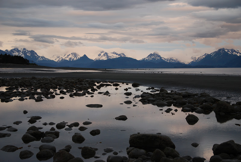
| Low tide, Katchemak Bay |
We walked back along the opposite side of the street and on the beach a short ways. The beach is an accumulation of flat and round rocks varying from the size of a quarter to that of a basketball, making a nice romantic stroll look more like two staggering drunkards.
We returned to the RV for happy hour and cards while awaiting low tide. At close to 9:30pm we walked out onto the rocky tidal flats stretching out in front of the RV. The seagulls ran at the edge of the surf and picked at the mussels strewn about the tide pools. The snow-capped Kenai Mountains looked beautiful in the little bit of evening sunshine shining down on them from under the thick clouds.

Hoping to catch a glimpse of more wildlife, we drove to
Bishop's Beach back in town. Working our way carefully down the slope to the beach there, we saw the makings of a perfect beach evening. A nearby bar hosted a band whose music drifted out toward us from our left, and a small bonfire warmed the folks tending it off to our right. Straight out we walked over a field of big rocks, increasingly slimy as we neared the sand bar beyond them. The sand bar is where the razor clams hide and locals go clamming for them during
extreme low tides. Tonight, though, no one was out working and the few folks we saw were enjoying the cool summer evening relaxing. A couple of paddleboarders came in from sea, another group walked with their dog on the rocks, and we took pictures of the bay and the mountains while listening to the music and smelling the wood burning in the bonfire. Wow. The average high temperature in the summer here is 60 degrees, the low only 46 degrees. With today's high temperature at only 52, it got quite chilly in the evening, so no toe-dipping tonight. Reluctantly we returned to the car and drove back to the RV.
 |
| Bishop's Beach |
On Monday, we awoke to the sounds of our fellow RVers moving around outside, as well as the seagulls calling to one another overhead. Our day began with a visit to the
Alaska Islands and Ocean Visitor Center where we watched a short film about the
Katchemak Bay Research Reserve. The Reserve functions to educate the community about the bay's wildlife, habitats and need for protection.
 |
| Bishop's Beach at extreme low tide |
A short walk out the back of the building led us down a path through the wetlands to
Bishop's Beach again, where we strolled on the vast stretch of land exposed by the extreme low tide today at noon. Stepping carefully through the water and sand, we walked as far out as the tide would allow and then made our way near some seabirds picking through the rocks for food. Realizing the low tide point had passed, we headed back in to avoid being cut off with the rising water and having to wade through it to return to shore.
Back on dry land, we walked toward the
visitor center then detoured over a foot bridge near the
Beluga Lake Slough. The slough is a saltmarsh flooded twice daily by the rising tides whose grasses feed and protect seabirds and other animals throughout the year. We returned to the visitor center and watched another film, 'Journey of the Tiglax', before listening to a ranger talk. Both the film and the ranger discussed the Herculean efforts of
Bob 'Sea Otter' Jones to save the native seabirds of the Aleutian Islands from the ravages of introduced predators -- foxes and rats.
 |
Cute Sea Otter!
(pic by Mike Baird, from Wikipedia) |
Jones was also instrumental in the replenishment of the sea otters along the southern coast of Alaska. Sea otters, whose fur is the thickest and warmest of any animal on Earth, were hunted to near extinction first by Russian fur traders beginning in the late 1700s and subsequently by the Americans after Alaska's purchase. With the establishment of the
Alaska Maritime National Wildlife Refuge and through the efforts of dedicated conservationists, the sea otters' population has seen a resurgence and they have spread once again throughout the islands and eastward to the southeastern Alaskan coastline. These adorable swimmers can be seen in tourist brochure pictures floating on their back, feet up and ridiculously cute. Ha!
 |
| Boardwalk on Beluga Lake Slough |
We walked through the museum exhibit which highlighted the habitats of the animals now protected by the Refuge as well as the past impacts by non-Native people on them, such as the military occupation during WWII, the intentional introduction of foxes (and unintentional one of rats) as well as the zealous market hunting of sea otters, fur seals, walruses and several types of whales.
Evidence exists showing Native people had co-existed successfully along the
Aleutian Islands with the animals for over 9,000 years until contact with Russian traders brought disease, forced relocation, slavery and death. The descendants of those who survived the two centuries of enslavement still call the islands home. What a fascinating
visitor center and museum.
 |
| Cosmic Kitchen |
We headed out for lunch and quickly decided on the
Cosmic Kitchen. This quirky little restaurant served us the tastiest meal we've so far eaten in the entire state of Alaska, Yukon and all of British Columbia. Ken opted for the daily lunch special of a grilled salmon quesadilla and I chose the turkey burger. Both were excellent, served in a homey atmosphere with a smile, and reasonably priced. What a breath of fresh air over most of the restaurants we've tried in the last 5 weeks or so.
We continued our tour of Homer by driving to the end of East End Road where the views of the
Katchemak Bay are spectacular. The 3 glaciers we could easily see across the water truly looked like rivers of ice frozen in place between the black mountain cliffs. The fjords drop precipitously to the bay below while the clouds and the sun vie for the peaks.
 |
View of Homer Spit and Katchemak Bay,
with Beluga Lake in foreground |
Next we found Skyline Drive, a road whose higher altitude allows even larger views of the bay and the Kenai Mountains. The toe of the Wosnesenski Glacier dips almost to the waterline while the Grewingk and Portlock Glaciers peek out from their high perches above the bay. We could spot Fire Island off in the distance, as well as Homer Spit, whose bisection of the Katchemak Bay separates the salt water of the Cook Inlet on the west side from the glacial melt freshwater on the other. With tide changes nearing 28 vertical feet here, the different nutrients in the glacial freshwater and ocean saltwater combine to nourish the huge variety of seabirds, fish and plankton that live near this estuary.
 |
| Wosnesenski Glacier |
We soaked up as much of the view as the drizzle and clouds would allow, thankful that we could see anything at all. We made our way back to the coach (and again past the bald eagle who has taken up residence atop a specific pole next to the road) for afternoon tea and dinner and an evening of hilarity playing cards out of the ever-present rain.
We're starting to grow moss.

 When we pulled into a scenic overlook just north of Homer, our ultimate destination, only a little bit of the view wasn't obscured by fog. By the time we got out of the RV, the overlook was completely covered in a fog so thick we couldn't even see the opposite side of the road, never mind any of the rumored vista. We waited patiently for the fog to lift even a little, but for all of the 20 minutes we were there, it did not.

 Hoping to catch a glimpse of more wildlife, we drove to Bishop's Beach back in town. Working our way carefully down the slope to the beach there, we saw the makings of a perfect beach evening. A nearby bar hosted a band whose music drifted out toward us from our left, and a small bonfire warmed the folks tending it off to our right. Straight out we walked over a field of big rocks, increasingly slimy as we neared the sand bar beyond them. The sand bar is where the razor clams hide and locals go clamming for them during extreme low tides. Tonight, though, no one was out working and the few folks we saw were enjoying the cool summer evening relaxing. A couple of paddleboarders came in from sea, another group walked with their dog on the rocks, and we took pictures of the bay and the mountains while listening to the music and smelling the wood burning in the bonfire. Wow. The average high temperature in the summer here is 60 degrees, the low only 46 degrees. With today's high temperature at only 52, it got quite chilly in the evening, so no toe-dipping tonight. Reluctantly we returned to the car and drove back to the RV.


