 |
| Taiya River |
 |
| Wild Irises |
On Saturday morning, we started chatting with some neighbors
in the RV park who also happened to be at last night’s theater production.
Donna was the audience member swindled of her $20 for a lousy bar of soap while
Jerry took pictures from the front row. They both had taken pictures throughout
the production, including my sorry turn in the can-can line, and so offered
them to us. Ken jumped at the chance. Thanks. In any case, we four chatted for
quite some time about all things Alaskan to do and see, it was great!
 |
| Lupine |

Later, after some chores, we drove out of town to see the
historic site of the competing gold rush town,
Dyea (pronounced die-EE), where
the gold seekers hoped to scale the
Chilkoot Trail on their way to Dawson City
and the gold fields. The town was settled at the mouth of the Taiya River on a
huge stretch of shallow tidal flats, meaning the large vessels from Seattle and
San Francisco carrying stampeders and their provisions to Dyea had to dock far
out from town and then have the people and items ferried in on little boats,
unlike Skagway’s deep port and wharf at the town’s edge.
 |
| Real Estate office false front |

Like Skagway,
Dyea maintained a transient population of
thousands of gold rushers beginning in July, 1897. But following the disastrous
April 3rd, 1898, avalanche on the Golden Staircase of the
Chilkoot Trail and the development of the White Pass and Yukon Route railroad out of
Skagway, by 1903
Dyea had been reduced to a population of only 3 souls. A cemetery in the woods are where most of the folks killed in the avalanche were buried.

All
that remains now of the town’s carefully platted streets and once bustling
throngs of businesses are the ruins of an old warehouse (read: a pile of lumber
rotting into the ground), some pieces of an old rowboat, the false front of an
old real estate office formerly on Main Street, and the odd artifact or two
under the trees and moss that have grown over everything.
 |
| Taiya River near Dyea |
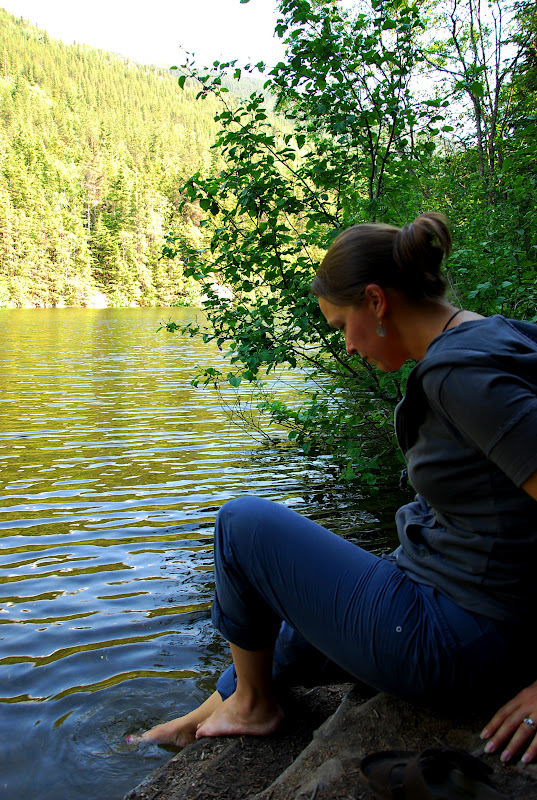
The approach to Dyea allowed us to easily compare the geography
of the two gold rush towns’ locations and Skagway’s advantages were readily
obvious. However, the tidal flats where
Dyea once stood are now beautiful
marshes with ribbons of glacial water from the Taiya River flowing through
them. We drove out onto the flats where several folks had set up their campers
and others were taking photographs or walking their dogs. With the warmest day
yet in the Skagway area, I just had to dip my toes in the chilly water…so nice
for a split second and then the bones of my feet and ankles began to ache and
throb in the arctic chill. Brr. We started back to Skagway but stopped at a
scenic overlook of the town where we could see the port and harbor and much of
the town itself.
 |
| Scenic overlook of Skagway from Dyea Road |
After lunch in the RV, we returned to the
Moore House, which
we had briefly visited a couple of days earlier on our guided tour. We took
more time to read about
Capt. William Moore, his son Ben and their family’s
impact on the town’s development. Several rooms in the little house have been
restored to much the way the Moores had them when they lived there until 1905.
 |
View of Skagway from the
Dewey Lakes Trail |
Next we walked over to the
Skagway Museum, a lovely collection of all things
Skagway, including the town's history during both the gold rush as well as World War
II. We watched a film on the US Army’s invasion of tiny Skagway in order to
provide material support to the teams building the Alaska-Canada Military
Highway (the Alcan Highway, now called the Alaska Highway) via the town’s
railroad to Whitehorse, the mid-point on the highway project. The highway was
built so the US government could truck airplanes into Alaska to be sent to the
Soviet Union to fight Hitler’s invading forces. Once the Japanese landed on the
Aleutian Islands on the opposite side of Alaska, Skagway’s role became even
more important both in supporting the highway’s construction and ferrying
soldiers from the port to the interior via the WP&YR Railroad. Fascinating.
We also saw exhibits about some of the early townspeople like the Moores, Soapy
Smith, and Harriet Pullen. Other exhibits highlighted the
Native Tlingit items
used for centuries in the area before the stampeders arrived. The museum was
really interesting.
 |
Tlingit petroglyph along
the Dewey Lakes Trail |
Not wanting the touring fun to end, we hiked up to
Lower Dewey Lake, a trail advertised as ‘moderate’, but whose description does NOT
match its intensity. We huffed and puffed our way up a steep path gaining 500
feet in elevation in only 350 feet of trail. After that it leveled off, and
thankfully, so did our heart rates.


After much sweating we finally reached the
lake and both stuck our feet in to cool off. The water feels like melted snow
because, well, it is. We stayed there for a few minutes letting our tired feet
enjoy the cool water while the mosquitoes enjoyed us. Nice.
We hiked back down
the side of the mountain and into the
Red Onion Saloon, whose accompanying Brothel Museum is pitched as "15 minutes for $5, Just like in 1898!" Nice, though it was closed when we were there. We shared a pitcher of beer
and a light dinner of salmon dip with pita points and a mozzarella caprese
sandwich. Very tasty…and, as it turns out, our nice waitress, Kendall, is from
DC! She was wearing a
DC Brau Brewing Company t-shirt with the motto ‘Fermentation without
Representation’ on the back, so we got into a lengthy discussion about all
things DC. It was great. We retired to the RV to rest up for our super duper
boat trip to Juneau tomorrow. We can’t wait!


 Later, after some chores, we drove out of town to see the
historic site of the competing gold rush town, Dyea (pronounced die-EE), where
the gold seekers hoped to scale the Chilkoot Trail on their way to Dawson City
and the gold fields. The town was settled at the mouth of the Taiya River on a
huge stretch of shallow tidal flats, meaning the large vessels from Seattle and
San Francisco carrying stampeders and their provisions to Dyea had to dock far
out from town and then have the people and items ferried in on little boats,
unlike Skagway’s deep port and wharf at the town’s edge.
Later, after some chores, we drove out of town to see the
historic site of the competing gold rush town, Dyea (pronounced die-EE), where
the gold seekers hoped to scale the Chilkoot Trail on their way to Dawson City
and the gold fields. The town was settled at the mouth of the Taiya River on a
huge stretch of shallow tidal flats, meaning the large vessels from Seattle and
San Francisco carrying stampeders and their provisions to Dyea had to dock far
out from town and then have the people and items ferried in on little boats,
unlike Skagway’s deep port and wharf at the town’s edge. 
 Like Skagway, Dyea maintained a transient population of
thousands of gold rushers beginning in July, 1897. But following the disastrous
April 3rd, 1898, avalanche on the Golden Staircase of the Chilkoot Trail and the development of the White Pass and Yukon Route railroad out of
Skagway, by 1903 Dyea had been reduced to a population of only 3 souls. A cemetery in the woods are where most of the folks killed in the avalanche were buried.
Like Skagway, Dyea maintained a transient population of
thousands of gold rushers beginning in July, 1897. But following the disastrous
April 3rd, 1898, avalanche on the Golden Staircase of the Chilkoot Trail and the development of the White Pass and Yukon Route railroad out of
Skagway, by 1903 Dyea had been reduced to a population of only 3 souls. A cemetery in the woods are where most of the folks killed in the avalanche were buried.  All
that remains now of the town’s carefully platted streets and once bustling
throngs of businesses are the ruins of an old warehouse (read: a pile of lumber
rotting into the ground), some pieces of an old rowboat, the false front of an
old real estate office formerly on Main Street, and the odd artifact or two
under the trees and moss that have grown over everything.
All
that remains now of the town’s carefully platted streets and once bustling
throngs of businesses are the ruins of an old warehouse (read: a pile of lumber
rotting into the ground), some pieces of an old rowboat, the false front of an
old real estate office formerly on Main Street, and the odd artifact or two
under the trees and moss that have grown over everything.


 After much sweating we finally reached the
lake and both stuck our feet in to cool off. The water feels like melted snow
because, well, it is. We stayed there for a few minutes letting our tired feet
enjoy the cool water while the mosquitoes enjoyed us. Nice.
After much sweating we finally reached the
lake and both stuck our feet in to cool off. The water feels like melted snow
because, well, it is. We stayed there for a few minutes letting our tired feet
enjoy the cool water while the mosquitoes enjoyed us. Nice.
No comments:
Post a Comment